Hello Aspirants, and Welcome to ExamYog 🙏
If you are preparing for the UPSC, SSC, NDA, CDS, IAS, IPS, IFS, IRS, Railways, State PSCs & more exams, it is important to clearly understand the Physiography of India under the Indian Geography section of General Studies. Thus ExamYog brings with a NCERT based note of Northern Mountain region or the Himalayan region of Indian Geography. Here you can get the root level clarity based on your exam pattern.
This study guide provides a detailed review of the physical structure and geographical divisions of the Indian landmass based on geological history and tectonic activities.
India's physical structure is a result of long and complex geological history involving various tectonic activities such as folding, faulting, volcanic eruptions, metamorphism, and sedimentation. It includes diverse landforms such as the Himalayas, plains, plateaus, deserts, coastal plains, and islands. Approximately 10.77% area is occupied by Mountains, 10.77%
by Hills, 27.7% by Plateaus and 43.2% by the Plains.
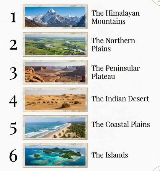
📚 The Indian landmass can be broadly divided into the 6 physiographic divisions:
1. The Northern and North-eastern Mountains ✅
2. The Northern Plains
3. The Peninsular Plateau
4. The Indian Desert
5. The Coastal Plains
6. The Islands
The Northern and North-eastern Mountains
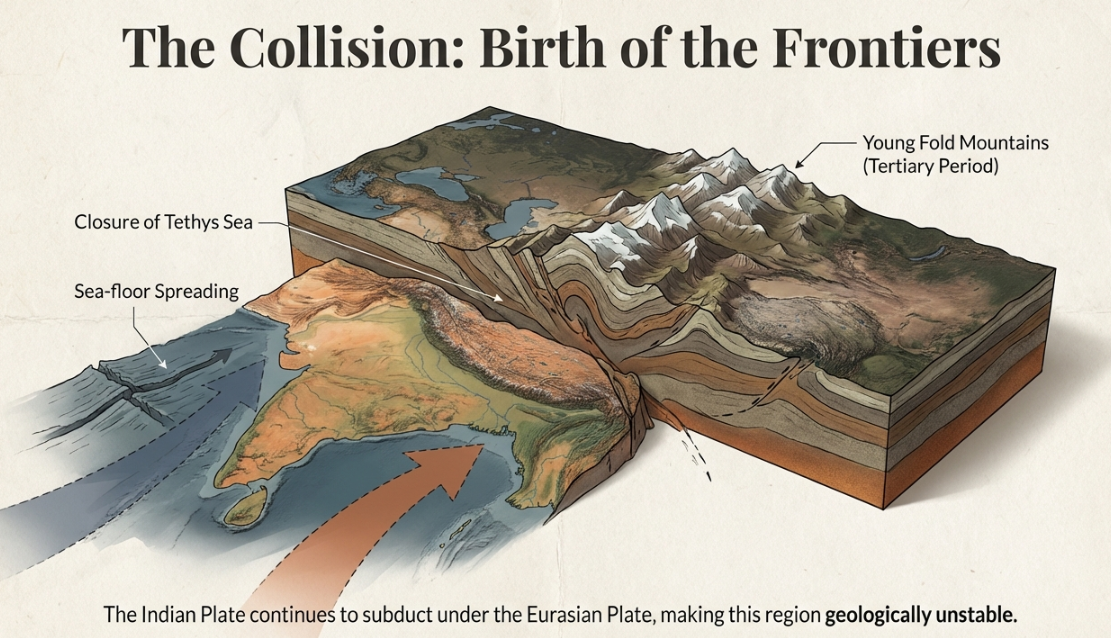
Origin and Formation of Himalayas
- Plate tectonic theory based on the concept of Sea-floor Spreading (given by Harry Hess) best describes the Origin of the Himalayas.
- Formed during the Tertiary period due to the collision of the Indian plate and the Eurasian plate
- Indian Plate getting Sub-conducted under the Eurasian Plate .
- The upliftment of the Himalayas took place in different phases, with the Shiwalik being the newest .
Vertical or Latitudinal division of the Himalayas
- Trans Himalayas
- Greater Himalayas
- Lesser Himalayas
- Shiwalik Himalayas
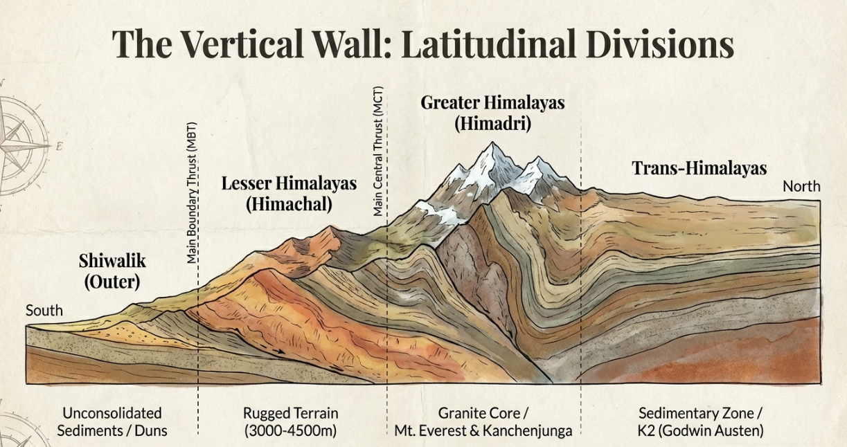
1. Trans Himalayas/ Tibetan Himalayas:
- These ranges have been found from Sedimentary rocks .
- The rocks from Tertiary period to Cambrian period are found here
- Antecedent rivers like Indus, Sutlej, Brahmaputra originate from this range.
- Highest mountain peak of this range is K2 (Godwin Austen) at POK in Karakoram range.
- Trans Himalayas and Greater Himalayas are divided by ITSZ (Indo-Tsangpo-Suture-Zone)
- Karakoram, Ladakh, Zaskar, Kailash are the important ranges of this region.
Karakoram Range
- Highest peak of Karakoram range is K2 (Godwin Austen)
- Siachen (76 km), Biafo (63 km), Baltoro (62 km), Hispar (61 km) are the four major Glacier in the Karakoram range.
- Siachen is known as ‘White water in India’, located at Nubra valley.
- K2 is also known as ‘Savage’ mountain because of its dark history and incredibly high death.
- Rakaposhi is one of the World’s steepest mountain peak located in Karakoram range at Gilgit-Baltistan in POK.
Ladakh Range
- Highest peak of Ladakh range is Stok Kangri.
Zaskar Range
- Highest peak of Zaskar range is Kamet.
Kailash Range
- Highest peak of Kailash range is Kailash.
2. Greater Himalayas/ Centre Himalayas:
- Greater Himalayas known as the Inner Himalaya or Himadri.
- Great Himalayan ranges is also known as the Central Axial ranges.
- Average highest of this region is 6100 m. and width of 25 km.
- Contains major peaks of the World like, Nanga Parbat (8124 m), Nanda Devi (7816 m), Mt. Everest (8848.86 m), Kanchanjunga (8598 m), Kamet (7756 m), Namcha Barea (7765 m).
- Important Pass: The Burzil pass and Zojila pass in J&K, Bara Lacha pass and Shipkila pass in Himachal Pradesh, The Thagala pass, Niti pass and Lipu Lakh pass in Uttarakhand and the Nathula pass, Jelep La in Sikkim.
- The Great Himalayas is separated from the Lesser/Middle Himalayas by the Main Central Thrust (MCT).
3. Lesser Himalayas/ Middle Himalayas:
- This region known as Himachal.
- The average highest is 3000-4500 m and width/breadth 60-80 km.
- Kashmir valley and Lahul, Spiti, Kangra and Kullu Valley of Himachal Pradesh are located here. This ranges are also famous for Hill Stations like, Shimla, Almora, Nainital, Ranikhet and Darjeeling.
- Middle Himalayas and Shiwalik Himalayas are divided by the Main Boundary Thrust (MBT).
- Ranges: Pir Panjal, Dhauladhar, Nag Tibba, Mahabharat.
Pir Panjal Range
- Pir Panjal ranges located in Kashmir, and it is the longest and most important range of the Himalaya.
- Two famous passes present in Pir Panjal range are Burzila pass and Banihal pass.
- Karewas are alluvial deposits of different Soil and sediments such as sand, Clay, Silt, Shale, Mud, Lignite and Loess found on the slop of Pir-Panjal in J&K .
- Karewas are well known for the cultivation of Saffron called Zafron.
- Karewas are also found in the valley of Bhadarwa valley.
4. Shiwalik Himalayas/ Outer Himalayas:
- Shiwalik Himalayas are formed in ‘Cenozoic Era’.
- The southern and the outermost ranges of the Himalayas are known as the Shiwalik.
- Shiwalik Himalayas are the youngest mountain ranges of the Himalayas.
- Average highest 600-1200 m and breadth is about 10-50 Km.
- This ranges are composed of the unconsolidated sediments brought down by rivers from the main Himalayan ranges located fer in the north. These valleys are covered with thick gravel and Alluvium.
- Longitudinal Valleys, conical forests, and small grasslands are found between the southern slopes of the Middle Himalayas and the Shiwalik ranges, which are known as Duns in west, Duars in East, Bugyals in Uttrakhand and also known as Medos.
- The lower region of Shiwalik Himalayas is known as Terai.
- Shiwalik Himalayas are separated from the Ganga plains by Himalayan Front Fault (HFF).
- Famous Duns: Dehradun, Kotlidun, Patlidun.
- Famous Duars: Haridwar.
Key Facts:
- Pamir Knot: Junction of notable mountains like Tain Sham, Karakoram, Kunlun, Hindu Kush, and Himalayan Mountain range.
- Hindu Kush: Covers Afghanistan, Pakistan, Tajikistan.
- The Siwalik Himalayas are called in Arunachal Pradesh are Dhang.
- Old name of Mt. Everest- Peak (XV).
- Highest peak of India – K2 (8611 m). Located in Karakoram range (Trans Himalayas)
- Highest peak of India in Himalaya- Kanchanjunga (8598 m).
- Undisputed highest peak of India is- Nanda Devi (7817 m).
- Highest of all fold mountains of the world- Himalaya.
- Oldest fold mountain in India is Aravalli.
- Longest of all Fold mountains in the World is Andes (Chile, South America).

Horizontal or Longitudinal division of the Himalayas
Sir S. Burrad divided the Himalayas longitudinally into 4-sub divisions based on river valleys.
- Kashmir Himalayas
- Kumaon Himalayas
- Nepal Himalayas
- Assam Himalayas
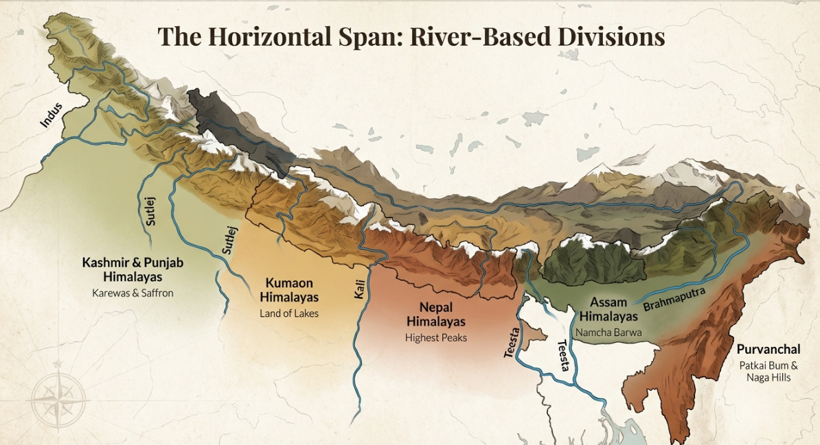
1. Kashmir/ Punjab Himalayas:
- Laying between from the Indus River in the west to the Sutlej River in the east .
- This region includes the Union Territories of Jammu & Kashmir, Ladakh and Himachal Pradesh which covers Karakoram, Ladakh, Zaskar, Pir-Panjal and Dhulandhar ranges.
- Stretches for 560 Km, It the widest part of Himalayas with an extension of 250-400 Km.
- The famous glacier of south Asia like, Siachen and Baltoro are located in this range. Fresh water lake like Dal and Wular and Salt water lake like, Pangong Tso and Tso Moriri are found here.
2. Kumaon Himalayas:
- It has wide area of 320 Km between the Sutlej in the west and Kali River in the east in Uttrakhand.
- Highest peak of this region is Nanda Devi (7817 m).
- Western part known as Garhwal Himalayas and Eastern part known as Kumaon Himalayas. The altitude of Kumaon Himalayas is more as compared to the Kashmir/Punjab Himalayas.
- Badrinath, kedarnath, Trishul, Mana, Gangotri, Nanda Devi, Kamet etc. are the major peak of this range.
- The origins of Ganga and Yamuna rivers, Gangotri and Yamnotri glaciers are located here.
- Lakes: Nainital, Bhimtal, Sattal in Uttrakhand are located in this range.
- Passes like Mana and Niti are also located here.
3. Nepal Himalayas:
- It extends upto 800 km between Kali River (Sharda) in the west and Teesta River in the east.
- Nepal Himalayas is higher in altitude as compared to the Kumaon Himalayas.
- This range known as This range known as Sikkim Himalayas in Sikkim, Darjeeling Himalayas in West Bengal and Bhutan Himalayas in Bhutan.
- Highest peaks are Mt. Everest, Annapurna, Dhaulagiri, Makalu, Kanchanjunga etc.
- It is the most prominent and massive portion of the Himalayas, containing some of the highest peaks in the world; Mount Everest, Annapurna, Dhaulagiri, Makalu, Kanchanjunga etc.
4. Assam Himalayas:
- It extends upto 800 km between Kali River in the west and Teesta River in the east, which is less altitude as compared to the Kumaon Himalayas and Nepal Himalayas.
- It is spread in the Indian states of Assam, Arunachal Pradesh, Sikkim and Bhutan.
- Namcha Barwa is the Highest peak of this range.
- Jelep la, Bondi La, Sela, Yangyap and Karpo La are the important passes located in this section.
Key Facts:
- Shimla is located in Dhauladhar range.
- Kashmir Himalayas are famous for Karewas.
- The valley of Kashmir is located on a tectonic Nappe structure.
- ‘Tal’ means Lake like Nainital, Bhimtal etc.
- ‘La’ means Pass like Jelep La, Bondi La etc.
- ‘Milam’ glacier located at Pithoragarh district (Uttarakhand) in Kumaon Himalayas.
- Mount Everest also known as Sagar Matha in Nepal, which means ‘Forehead of the Sky.’
- In Tibet, Mount Everest is called Chomolungma, which means ‘Goddess Mother of the World.’
- In India (especially in traditional or religious contexts), it is sometimes referred to alongside Mount Gaurishankar, a nearby sacred peak in Nepal, but Gaurishankar is a separate mountain, not an alternate name for Everest.
The Eastern Himalaya or Purvanchal Hills
- The Eastern Himalayas, also referred to as the Purvanchal Hills, constitute the easternmost extension of the Himalayan Mountain system in India.This region spans across the eastern part of Arunachal Pradesh, and continues through Nagaland, Manipur, Mizoram, Tripura, and parts of Meghalaya and Assam.
- After crossing the Dihang or Brahamaputra gorge, the Himalayas take a sudden south ward turn and form a series of comparatively low hills running in the shape of a Erescent (half Moon).
- In the North, they are known as Patkai Bum, which are forms the international boundary between A.P and Myanmar
Key Facts:
- Garo, Khashi, Jaintia hills were formed in the same age as Malwa Plateau.
- West to East: Garo- Khasi-Jaintia- Mikir- Naga.
- North to South: Patkai Bum- Naga- Mani- Mizo.
- Mizoram is also known as Molassis Basin.
- ‘Arakan Yoma’ is the extension of Himalayas, located in Myanmar.
- The mountain range lies between Indian and Myanmar is Lushai hill (Lushai hills also known as Mizo hills).
- The Blue Mountain locally known as Phawngpui is the highest peak of Mizoram, located in the Lushai Hills near the Myanmar border.
Important Peaks of the Himalayan Mountains
| Peak | Country | Height (m) |
|---|---|---|
| Mount Everest | Nepal | 8,848.86 m |
| K2 (Godwin Austen) | Ladakh, India | 8,611 m |
| Kanchenjunga | Sikkim, India | 8,598 m |
| Nanga Parbat | Ladakh, India | 8,124 m |
| Nanda Devi | Uttarakhand, India | 7,816 m |
| Kamet | Uttarakhand, India | 7,756 m |
| Namcha Barwa | Arunachal Pradesh, India | 7,756 m |
🎯For detailed NCERT-based notes on the Physiographic Divisions of India
Read the complete NCERT-based notes on the Physiographic Divisions of India for clear concept understanding and exam-focused preparation.
📢 Practice Physiographic Division of India PYQs on ExamYog
Practice Physiographic Division of India Official PYQs of different exams only on ExamYog based on its year’s exam pattern to improve accuracy and time management.
❓ Northern Mountain Region of India FAQs
- What is the northern mountain of India?
Ans: The northern mountains of India are known as the Himalayas. They form a natural boundary in the north and protect India from cold winds coming from Central Asia.
- Which is highest, K2 or Nanga Parbat?
Ans: K2 is higher than Nanga Parbat. K2 is the second-highest peak in the world with an altitude of 8,611 m, while Nanga Parbat is lower in height with 8,124 m height.
- What is another name for the Northern Mountains?
Ans: Another name for the northern mountains is the Himalayan Mountain System.
It includes several parallel ranges like the Greater, Lesser, and Shiwalik Himalayas.
- Which mountain is called Killer mountain?
Ans: Nanga Parbat is called the Killer Mountain. This name is given due to its steep slopes, frequent avalanches, and high number of climbing accidents.
- Which is the 3 highest peak in India?
Ans: The third highest peak in India is Kanchenjunga with an altitude of 8,598 m. It is located in Sikkim and lies on the India–Nepal border.
- Which Himalaya is known as Shivalik?
Ans: The outermost and lowest range of the Himalayas is known as the Shivalik Hills. These hills are made of loose sediments and are prone to erosion with an average highest 600-1200 m and breadth is about 10-50 Km
- Which is India's 2nd highest peak?
Ans: Nanda Devi is the second-highest peak entirely within India. It is located in Uttarakhand in **Garhwal hills.
- What is the old name of Shivalik?
Ans: The old name of the Shivalik range is Manak Parvat. This name is found in ancient Indian texts and historical references.
- What is Pir Panjal and Dhauladhar range?
Ans: The Pir Panjal Range and Dhauladhar Range are sub-ranges of the Lesser Himalayas. They run mainly through Jammu & Kashmir and Himachal Pradesh. Two famous passes present in Pir Panjal range are Burzila pass and Banihal pass.
- How are mountains named?
Ans: Mountains are usually named based on:
- Local language or culture
- *Nearby rivers or regions
- Mythological or religious beliefs
- Explorers or historical references
🔔 Join ExamYog Groups to Stay Regularly Updated
To stay consistently updated, join our Telegram, WhatsApp, Facebook, YouTube, and Instagram groups and pages, where you get Free Chapter-Wise PYQs, Subject-Wise Mock Tests, Static GK Blogs, Daily Current Affairs, and Study Notes. If you want regular guidance and timely updates for your exam preparation, join now and stay updated with ExamYog – Your Online Mock Test Partner.
📩 Drop a Suggestions?
ExamYog is built completely for the aspirants, so your valuable feedback and suggestions truly matter to us. If you have any ideas or improvements to share, please click the link below and let us know your thoughts. Your feedback helps us make the platform better for you and everyone.